
Path to a permit
What work does NOT need a permit?
Minor cosmetic changes like painting, replacing flooring, installing new cabinet doors, small fence repairs, minor electrical repairs like replacing light switches, and small landscaping projects like planting shrubs or adding mulch
What work needs a permit?
Everything else.
What is needed to submit for a permit?
To submit a permit for a home remodel, you typically need to provide a completed application form, detailed construction plans including architectural, structural, electrical, and plumbing drawings, specifications outlining materials and methods, and may need to include calculations like structural or energy calculations depending on the project's complexity; all documents should comply with local building codes, and you may also need to pay a permit fee.
Key components to submit:
Application form: Completed permit application with project details and owner information.
Construction plans:
Architectural drawings showing room layouts, wall locations, door and window placements.
Structural drawings detailing load-bearing walls, beams, and support systems.
Electrical plans showing wiring locations and circuits.
Plumbing plans illustrating pipe runs and fixture placement.
Specifications: Written document describing materials, construction methods, and finishes used in the project.
Calculations (if needed): Structural calculations for significant changes to load-bearing elements, energy efficiency calculations depending on local regulations.
Site information: Property details like legal description, zoning, and existing conditions.
Permit fees: Payment of the required permit fee based on project scope.
Important points to remember:
Check local requirements:
Contact your local building department to verify the exact documents needed for your specific project as regulations can vary by location.Professional assistance:
For complex remodels, consider consulting an architect or engineer to prepare accurate plans.Inspections:
Once the permit is issued, expect inspections at various stages of construction to ensure compliance with building codes.

TYPES OF PERMITS
Maintenance permit online:
Electrical – circuits, outlets, service upgrade, EV charging station, etc.
Plumbing – gas service/piping, bath/kitchen plumbing fixtures, water heater
Mechanical – ductwork, mechanical appliance, HVAC, exhaust hood
Building – siding, stucco, re-roof, same size/location window/door replacement
These online permits are for jobs that replace something that exists now. You do not need to have plans to describe your work. We will not ask for plans.
Minor improvement permit online:
Residential rooftop photovoltaic installations
Energy storage systems
Backup generator installations
Non-structural kitchen and bathroom remodel (not > 400 sq ft)
We review your plans at the job site. You receive your permit online up front. You don’t have to send your plans to us.
Big jobs need plans up front:
New buildings, additions, alterations, remodels, conversions
ADU’s (Accessory Dwelling Units), JADU’s (Junior Accessory Dwelling Units)
Decks, trellis, accessory structures
Pools, spa, hot tub
You need to submit your plans before we issue a permit. This option takes 6 – 8 weeks because it involves more collaboration. Sending plans on paper can slow the process down.
Submittal Requirements Checklist:
Depending on the specific scope and location of your proposed project, additional documentation may be required to obtain plan review approval and permit issuance. This may include, but is not limited to, the following:
-Structural Engineering, Civil Engineering, and Surveyor Plans, including boundary and topographic data
-Photometric Plans
-Grading and Drainage Plans
-Construction Management Plans, Erosion & Sediment Control Plans, and Stormwater Control Plans
-Site Accessibility and Utility Plans
-Access, Driveway / Access Road with Grade Profile, Parking, and Circulation Plans
-Parking Study, Traffic Study
-Emergency Evaluation Plan
-Engineer’s Structural Calculations
-Geotechnical Report, Recommendations, and Review Letter
-Energy Calculations and Reports (T-24)
-Installation Specifications for Major Appliances or Equipment
-Hydrologic and Hydraulic Calculations, per MCC24.04.520
-Marin County Green Building Requirements
-Marin County Low-Carbon Concrete Requirements
-Copy of Planning Permit / Planning Entitlement
-Copy of EHS Septic Permit, Septic Destruction Permit, and Water Permits, including Inspection of Septic System
-Arborist Report
-Biological Report
-Deferred Submittals:
Truss Calculations
Fire Sprinkler and/or any Fire Protection System Plans to Local Fire District
Vegetation Management Plans to Local Fire District
Solar per CF1R
-Landscape Plans
-Floor Plans (demolition plans, existing floor plans, proposed floor plans)
-Elevation Drawings

Example of existing floor plan and proposed floorplan
Title or Cover Sheet Requirements:
Project Documentation Requirements
Project Description: Clearly state the proposed type of project and scope of work
Directory or Index: Provide a directory or index of all drawing sheets
Deferred Submittals: List any deferred submittals
Data Table
Assessor Parcel Information:
-Number
-Address
-Zoning
-Size
-Number of Stories
-Floor Areas:
-Existing
-Proposed
-Total
-Floor Area Ratio (FAR)
-Applicable Edition of the California Building Standards Code
-Use Type for Each Building: Include occupancy group per code
-Types of Construction per Code
-Occupant Load Calculations per Code
-Existing and Proposed Fire Sprinklers and/or any Fire Protection System
-Certified Access Specialist (CASp) Report: Include status or exemption
Calculations for:
-Egress
-Vehicle and Bicycle Parking
-Plumbing Fixture Count
-EV Parking (for commercial)
General Sheet Requirements
Title Block
-Name and signature of the plan sheet preparer
-Professional stamp (if applicable)
-Address, phone number, and email address of the plan sheet preparer
Project Information
-Project Title
-Site Address
-Assessor Parcel Number (APN)
Plan Sheet Details
-Designation of the type of each plan sheet (e.g., Floor Plan, Elevations)
-Page Number
-Revision table showing dates
Scale: Minimum scale of 1/4” = 1’-0” unless otherwise noted
Additional Elements
-Vicinity Map
-North Arrow

Example of an RCP (reflected ceiling plan) - Electrical Plan
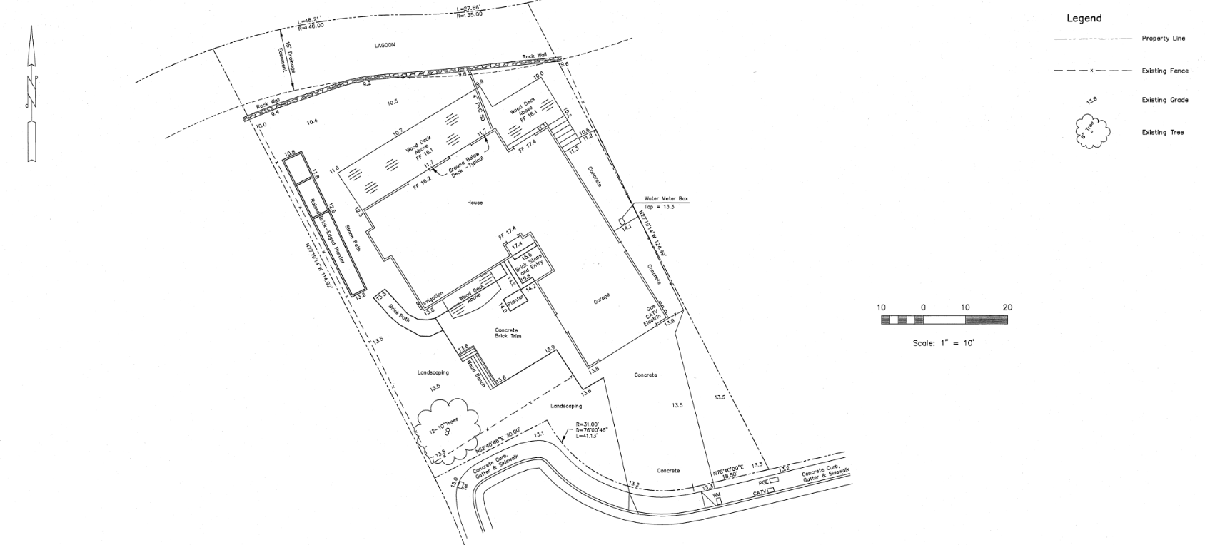
SITE PLAN REQUIREMENTS
Scale
Site Plans must be drawn in accordance with an accurate boundary line survey to a minimum scale of 1/8” = 1’-0” (architectural) or 1/10” = 1’-0” (engineering). Aerial photo site plans are not accepted.
Include the following:
Property Lines and Easements: Show all property lines with dimensions, all easements, required zoning setbacks (or building envelope), and include a North arrow.
Topographic Contours: Existing and proposed contours at 2-foot intervals, or sufficient spot elevations for flat sites. Use NAVD 88 for sites within 25 feet of sea level or in flood zones.
Finished Grade: Indicate finished grade elevations and contours.
Physical Site Features: Include wetlands, creeks or watercourses (indicate flowline, top of bank, and distances to top of bank for proposed work), trees (including those to be removed), vegetation, rock outcroppings, and springs.
Existing and Proposed Structures: Show all structures with distances to property lines, including building outlines with roof plan overlays, gutters, downspouts, drainage designs, stormwater collection facilities, and sizes/areas of new or replaced impervious surfaces. (Attach Grading and Drainage Plan)
New Structures and/or Additions: Overlay a roof plan on the topographic contours showing roof corners and ridgeline elevations. When natural grade no longer exists, interpolation of natural grade (based on surrounding natural grade) shall be shown in dashed contour lines through structure footprints.
Excavations, Cuts, and Fills: Show locations, areas, and quantities, including limits of disturbance. (Attach Grading and Drainage Plan)
Driveway Access: Include a dimensioned road plan with grade profile, parking, driveway slope, width, surface type, and maneuvering space.
Site Distance Analysis: Include references if required.
Commercial and Multi-Family Residential Projects: Show site circulation and maneuverability for fire trucks, garbage trucks, and delivery vehicles, including the size of each vehicle referenced.
Adjacent Streets and Easements: Show the full width of right-of-way, labels indicating public or private status, edges of pavement, bike paths, and all utilities and their locations. Indicate proposed improvements or work within the right-of-way.
Septic System and/or Water System: (For parcels with on-site water and sanitation)
Septic System: Include the size and location of the septic tank, any associated equipment, and the location of the disposal (leach) field and reserve leach field area.
Water Source: Indicate whether the source is a well or spring, and label it clearly.
Water System: Show and label the storage tanks and water treatment system.
Buildings: Label all buildings and structures connected to the water source.
Water Use: Specify if the water source is for potable use, irrigation, or both. If applicable, include the Permit-to-Operate (PTO) number.
Existing and Proposed Site Design Elements: Include retaining walls (with top-of-wall and bottom-of-wall elevations), walkways, fences, exterior lighting, vehicle access gates, mailboxes, rooftop and ground-mounted PV systems, generators, propane tanks, decks, detached platforms, docks, swimming pools and spas, outdoor kitchens and patios, gazebos and trellises, playgrounds and sports courts, and trash enclosures.
Flood Zone Attributes: For properties within a Flood Zone, include low and high tide contours, FEMA Special Flood Hazard Area designation, and boundary and base flood elevation.
California Accessibility Compliance: (for non-residential and multi-family uses): Identify public transportation and parking locations/layouts, all accessible routes (including slopes, surfacing, and clear widths), all publicly accessible buildings, facilities, or amenities associated with the project, exterior signage, and dimensioned and numbered parking spaces.
Example of topograhic notes
FLOOR PLANS
Existing and Proposed Floor Plans
Provide floor plans for both existing and proposed conditions, including a North arrow.
-Clearly identify the use of each room.
-Detail all proposed work, including exterior decks and patio features.
-Clearly show all doors and windows.
-Ensure that sections are correctly reflected in their locations on the floor plans.
-Include grid lines for clarity, ensuring that architectural and structural grid lines align.
-For major remodels, provide a clear scope of work across multiple plan sheets (e.g., Site Plan, Floor Plans, Elevations).
Wall Construction Legend
Include a legend on the plans indicating:
-Walls to remain
-New walls
-Walls to be modified
-Walls to be removed
-Include door and window schedules.

Example of a hand drawn Architectural Footprint (still accepted in many counties)
Additional Features
Mechanical, Electrical, and Plumbing
These features may be overlaid onto the Architectural Floor Plan or provided on separate Floor Plans.
Legend and Code Compliance Notes
Include a legend and provide code compliance notes for each feature:
-Mechanical features
-Electrical features (power, lights, alarms, switches)
-Plumbing features
Accessibility Compliance
-Demonstrate how the project meets California accessibility requirements for all non-residential and multi-family structures.
-Show paths of travel routes and other required accessibility features on the plan.

Example of elevation drawings of the exterior of a home
Exterior Elevations, Sections, and Roof Plans
Existing and Proposed Exterior Elevations
-Existing and proposed exterior grades
-Base flood elevation and finished floor elevations in FEMA Special Flood Hazard Areas
-Label each elevation as North, South, East, or West
-Describe all finish materials, noting those intended to comply with Fire Severity Zone requirements
-Dimensions from grade to each elevation
Existing and Proposed Cross-Sections
-Provide cross-sections through the lowest grades and highest roof elevations (include both directions).
-Indicate all interior heights and the overall structure height.
Include details on:
-Materials and methods of construction
-Interior heights
-Waterproofing details
-Types of insulation and methods of venting both the underfloor area and the attics

Example of interior Elevations including tile scope, wall panelings, lighting and millwork
Exterior Walls and Roof Details
Show existing AND proposed:
-Exterior wall assembly
-Roofing assembly, including eave, soffit, and gutter
-Solar equipment
-Chimneys
-Skylights
-Doors and windows
-Decks
-Porches
-Other features
Retaining Walls
Provide dimensioned elevations for both existing and proposed retaining walls, along with detailed cross-sections. Note: Detached retaining walls exceeding 4 feet in height may require additional building permits.
Fences and Vehicular Gates
Provide architectural elevations and details.
Non-Residential Signs, Towers, and Monuments
Provide architectural elevations and details.
California Accessibility Features
Include details as required for non-residential or multi-family projects, such as:
-Ramps
-Stairways
-Barriers
-Protruding objects
-ATMs
-Service and sales counters
-Other exterior features requiring access compliance
Existing and Proposed Roof Plans
Provide roof plans that show the following test:
-Existing and proposed hip, ridge, eave, and valley lines
-Heights of roof elevations
-Type of materials
-Roof slopes
-North arrow
-Downspouts
-Skylights
-Solar equipment (including setback distances)
-All other visual features

Example of proposed changes to an already approved floorplan - typically shown with “clouds” were changed occur
Structural Plans, Sections, and Calculations
Structural Drawings
List structural observations and special inspections.
Structural drawings must include dimensioned and annotated layouts and complete details for:
-Foundation, floor, ceiling, wall, and roof plans
-Truss layout plans and details
-Flood vents, including calculations and details (when applicable)
Structural Calculations
Provide two sets (when submitted on paper), double-sided on 8½ x 11 paper preferred
Structural calculations are required for detached structural retaining walls
Demolition Plans
-Existing walls to remain
-Existing walls to be removed
-Existing walls to be modified
-Walls to be modified must include all walls where any modification is proposed (e.g., shear walls, framing upgrades, new plate heights)
Zero Waste Marin Recycling & Reuse Plan
Demolition projects must submit a “J” Number
Erosion and Sediment Control
Include erosion and sediment control plans with demolition applications for an entire structure

Example of Structural As-Builts
Other Compliance Forms
Conditions of Approval
When required by your Planner, list Conditions of Approval from any separate Planning Permits (e.g., Design Review, Variance) on a separate, full-sized plan sheet placed at the front of the plan set. Include any other agency approvals.
Compliance with Building Inspections Verification Procedures
Adhere to Building Inspections Verification Procedures per Chapter 22.20, Marin County Code (Outdoor Construction Activities).
Biological Site Assessment
When required by your Planner for work within the Coastal Zone and San Geronimo Valley, provide a biological site assessment prepared by a qualified biologist. This assessment should identify Environmentally Sensitive Habitat Areas (ESHAs), wetlands, wetland conservation areas, streams, stream conservation areas, lakes, and coastlines, as applicable.
Constraints Map
When required by your Planner for work within the Coastal Zone and San Geronimo Valley, prepare a composite constraints map showing site boundaries and improvements overlaid with environmental constraints. This should be prepared by the project architect or civil engineer in consultation with other technical specialists.
In the Coastal Zone: Base the constraints map on the County’s Local Coastal Program (LCP) and relevant environmental studies. It should clearly show:
-Beaches, wetlands, streams, and lakes
-Mean high tide line
-Environmentally Sensitive Habitat Areas (ESHAs)
-Bluff top edges
-Top of bank of all streams
In the San Geronimo Valley: The constraints map should clearly show:
-Edge of any Stream Conservation Area
-Edge of riparian vegetation
-Top of bank
Soils / Geotechnical Reports
When required by the type and scope of the project and based on the Building Code requirements, provide Soils / Geotechnical Reports. Include the Geotechnical Engineer’s review letter addressing the professional review of civil plans for structural, grading, drainage, and stormwater control.
NOTE: Plans and other documents authored by licensed or registered California Design Professionals must be stamped and signed by the author.

Title 24 Energy Calculations
When required by the type and scope of the project and the California State Energy Code, provide Title 24 Energy Calculations on separate full-sized plan sheets to demonstrate compliance with the County’s Green Building Requirements.
NOTE: Substantial energy efficiency is required for new buildings, especially new single-family homes greater than 4,000 square feet. Consider these requirements early in project design.
CalGreen Checklist
When required by the type and scope of the project, provide a CalGreen checklist demonstrating compliance with the County’s Green Building Requirements.
Marin Low Carbon Concrete
When concrete is part of your project, include a compliance form for the County’s Low-Carbon Concrete Requirements in your plan set.
Grading and Drainage Plans
When required by the type and scope of the project, provide dedicated Grading and Drainage Plans, including erosion/sediment control and stormwater control plans.
Encroachment Permit
When required by the type and scope of the project, provide a separate Encroachment Permit application for any proposed work within a County-maintained street or right-of-way.
Site Distance Analysis
When required by the type and scope of the project, provide a Site Distance Analysis.